
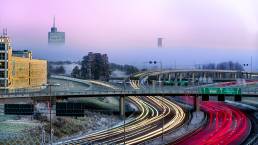
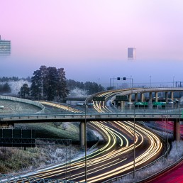
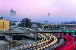
The power of data sharing
Towards sustainable mobility: The power of data sharing
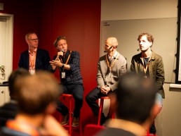
How can data make our transportation systems more efficient, eco-friendly, and tailored to people’s needs? A session during Mobility Day 2023 took on this big question, with experts in the field discussing how data isn’t just about numbers – it’s a key tool for making urban mobility smarter and more sustainable.
The panel – featuring representatives from Voi Technologies, The Swedish Transport Administration, The City of Stockholm and Univrses – highlighted the critical role of data in shaping a sustainable future for urban mobility.
The key takeaway was clear: relevant and actionable data is a critical element in creating transportation systems that are both resource-efficient and aligned with the needs of the community. For instance, the use of connected vehicles was described as a game-changing approach to collecting detailed data on traffic flow and user behavior, which can then inform everything from day-to-day road maintenance to long-term urban planning initiatives.
Shifting from the mere collection of data, the discussion also touched on its real-world applications. For transformative change, data needs to be part of multi-disciplinary strategies involving software developers, urban planners, and policymakers alike. This is where standardization becomes crucial. Consistent data-sharing protocols, developed and maintained at both national and international levels, were mentioned as a driving-force for the next big leaps in transportation efficiency and sustainability.
The panel also emphasized that the value of data goes beyond guiding vehicles or informing decision-makers; it’s also key in shaping public behavior and influencing policy. Understanding travel patterns and time metrics, for example, can help refine the system and ultimately encourage more sustainable mobility choices. Ethical considerations, particularly regarding data privacy and compliance with GDPR guidelines, were underscored as essential for responsibly moving towards a data-driven future.
Looking ahead, it’s clear that data and data-sharing will be central in advancing more sustainable and efficient mobility solutions, not least in urban areas. Working together – across industries and borders – is key. As Stockholm and Sweden work towards meeting ambitious sustainability goals, the effective use of data stands out as a common thread tying many efforts together.
Thanks to our panelists for contributing to this interesting discussion!
Gustaf Soldan Patrikson of Voi Technologies
Anders Asp of The Swedish Transport Administration
Robin Billsjö of The City of Stockholm
Jonathan Selbie of Univrses
Lucas Uhlén of Kista Science City
Curious about the topic and want to talk more? Reach out to Lucas!
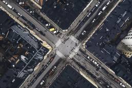
Sensorer i nytt samarbete för intelligenta trafiksystem
Nytt samarbete kring trafikanalys via sensortekniker identifierar nya lösningar för framtidens trafikmiljö.
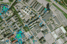
På en stolpe vid en fyrvägskorsning i Kista har multisensorer installerats – ett litet men viktigt steg på vägen att uppfylla stadens vision om att minska bilköer, trafikbuller och utsläpp av skadliga partiklar.
Stockholms stad, Kista Science City och flera teknikbolag utforskar tillsammans möjligheterna att mäta och analysera vägarnas trafikflöden mer intelligent, så att det blir lättare att sätta in rätt trafikåtgärder åren framöver.
Vilka fordonsslag ska få köra på vilka gator? Mellan vilka tidpunkter? Det är exempel på hur man med trafikstyrning kan påverka köer, buller och nivån av skadliga partiklar.
Utmaningen hittills har varit att man inte haft en tydlig bild av vilken trafik som kör på vilka gator. Datainsamling sker bara vid enstaka tillfällen per år, och har inte detaljerad information om vilka fordonsslag som passerar, vid vilka tidpunkter dessa passerar, eller i vilka hastigheter. Multisensor-teknik skulle kunna erbjuda allt detta – i realtid dessutom, året runt.
Ny och gammal teknik testas och jämförs
Men hur väl fungerar tekniken? Hur tillförlitlig är datan? Det är en av de saker som Stockholm stad vill ta reda på.
Testerna utförs i den relativt trafikintensiva korsningen Hanstavägen/Norgegatan i Kista . Riktigheten i datan är avgörande för att multisensorteknik ska ersätta dagens datainsamlingsmetoder. Den nya tekniken och den gamla räknar trafiken i den här korsningen, och resultaten jämförs även med ett ”människofacit”, där man räknat och klassificerat trafiken förhand.
”Här har man säkerställt att rätt personer är med”
Multisensorteknikerna som testas inkluderar bildanalys av registreringsplåtar (som vid vägtullar), radaranalys, och bild- och ai-analys av fordons former. Ändå är det inte tekniken som är avgörande:
– Utmaningen är att tekniken ska fungera i en stor skala i en komplex miljö, och tillföra stor nytta för staden. Omständigheter som GDPR, fysisk tillgång till ström och internetuppkoppling och belysning på platsen måste vägas in. Det är därför det här projektet är så värdefullt, säger David Eskilsson, vd på Edeva, ett av teknikbolagen som satt upp sensorutrustning vid korsningen.
– Här har man säkerställt att rätt personer är med, och vi abonnerar på deras tid. Vi teknikleverantörer får gå på djupet med alltifrån den it-säkerhetsansvarige på Stockholm stad till den som är ansvarig för alla trafikmätningar. Som litet teknikbolag är det vanligtvis i stort sett omöjligt att få till den här öppna dialogen med en stad. Det är guld värt.
Långsiktigt tänk med uppskalning i åtanke
David Eskilsson värdesätter också att projektet har ett långsiktigt tänk som går bortom ”proof of concept”:
– Att göra ”PoC:ar” leder ofta bara in i ett vakuum där inget sedan händer. Blicken nu är tydligt vänd mot slutvärdet och att vi ska hitta något som är tillräckligt bra och effektivt för att kunna skalas upp. Kista Science City har verkligen fått till en bra dialog mellan oss leverantörer och behovsägaren, säger David Eskilsson.
I mötet mellan Stockholms stad och teknikbolagen uppstår innovationskraft genom löpande feedbackmöten. Att samverka i en testbädd på det här sättet – med innovation och lösningar i fokus, och att successivt klargöra stadens behov och skruva på både tekniken och tänkbara lösningar i en iterativ process – är något annat än att mötas i en upphandling.
Använder Kistas infrastruktur för innovation
Lucas Uhlén, IoT-ansvarig på Kista Science City, leder projektet, som använder den infrastruktur för teknisk utveckling och innovation som redan finns i Kista:
– Vi vill erbjuda en arena där aktörer samverkar och snabbt och enkelt kan få tillgång till det urbana rummet, att testa, utveckla och visualisera lösningar med innovativ teknik för ett hållbart samhälle. Det har vi byggt upp här i Kista. Deltagarna har även tillgång till den community av andra partners, stakeholders och bolag som finns i vårt nätverk. På så sätt har de tillgång till andras perspektiv på hur lösningarna kan göras bättre eller kompletteras.
Maria Holm, ansvarig för projektet IoT Stockholm, Stockhom stad, om projektet:
”Vi är många som är angelägna om att Stockholm ska vara en attraktiv stad att bo och jobba i. Projektet är en viktig i del i vårt arbete med att få en bättre förståelse kring trafikflödena, så att vi kan se till att de fungerar optimalt framöver. Jag gläds enormt av det engagemang och den innovationsvilja som de inblandade aktörerna uppvisar. Näringslivets innovationskraft har en nyckelroll när vi skapar en hållbar framtid tillsammans.”
Projektet Multisensorer är en del av satsningsområde kring Intelligenta trafiksystem, som skapar förutsättningar för en unik insyn i dagens trafikflöden. En process och en fysisk plats där företag snabbt och effektivt får möjlighet att testa och utveckla sin teknik samt jämför lösningar med andra teknikledande bolag.
Läs mer on Intelligenta trafiksystem.
Shaping the future of mobility with AI and multisensors
Smart City
AI and multisensors to improve urban mobility
There are today several technologies through which city traffic and pedestrian flows can be operated and manage. At the same time, and as a result of our increasing mobility behavior, cities face severe challenges with congestion, accidents and air pollution.
The utilization of sensing technology in our streets
The utilization of sensing technology in our streets comes with many possibilities, as sensing and imaging technologies are becoming advanced and collect data using various types of scanning cameras and sensors equipped with AI.
-We need to make transport smarter, more robust and more sustainable. And we also need to think about the public space, so that we make it more accessible, attractive and available for all the people. These tests are very important because we need a place where we can test new technology.” says Maria Holm, Project Manager at the City of Stockholm.
Viscando, Qamcom and Savantic are all involved in ongoing tests to promote better traffic flows based on real time data, using multisensor and AI technologies installed on the streets of Kista.
– Traditional ways of measuring traffic flows are usually based on induction lines under the road surface or on tubes laid on the streets. Our goal with the test in Kista is to evaluate whether existing technologies such as multisensors and AI-based based technologies, can provide better results and added value for the city planners, says Anna Chiara Brunetti, Project Manager at Qamcom.
– If we would be able to plan the public transportation system in a data-driven way, that would lead to much more attractive public transportation and a more sustainable city, says Claes Orsholm, Founder & CEO at Savantic.
Call for action
Are you too a Stockholm-based SME developing solutions with the potential to transform the automotive industry and transportation system? Would you like to demonstrate your solution to a wider audience, or test together with a potential business partner within the ICT or automotive sector? Please contact sara.nozkova@kista.com.
Intelligent traffic management
Multisensors is part of the focus area “Intelligent traffic management“, creating prerequisites for unique insights into current traffic flows. A process and phsysical place where businesses quick and effective can test and develop their tech and to compare solutions with other technology leaders.

SMART
SMART
Intelligent traffic system
The project
Traffic congestion is a huge problem in urban areas. In Stockholm, car owners spend about 16 workdays stuck in traffic each year. Public transport is also affected by this, and during rush hours, bus services can suffer huge delays.
The objective of the Spatial Modelling Analytics & Real-time Tracking (SMART) Mobility Project is to mitigate growing urban traffic congestion challenges and associated issues of environmental degradation, economic inefficiency and negative impacts to the quality of life of citizens.
SMART Mobility will revolutionise the efficiency of traffic and commuting in cities by leveraging the capabilities of new 4D spatial technology and analysis platforms using real-time vehicle location and various movement data.
Several data sets
The project will use data from many different sources, including:
- Wifi data from Bumbee Labs. Position data is collected when smartphone searches for WiFi-connectivity. Bumbee Labs technologies utilizes this for crowd measurements and pedestrian flow, which is compliant with GDPR regulations.
- Vehicle data from Ramboll, Inrix and Tomtom. Through GPS, data such as speed and route can be obtained.
- Crowd data from Tre. Anonymize crowd data obtained from different sources, like cellular data and WiFi.
Project period
2020-2022
Partners
Ramboll
Bumbee Labs
Savantic
Tre
RISE
Contact
Eleonor Sjödin Turah
eleonor.sjodinturah@kista.com
Summary
SMART is a project that aims to create more effective traffic planning, with focus on public transport. The project will result in a prototype for a new platform, where many different data sets will interplay with AI technologies to predict congestion and plan routes accordingly.
The platform
The platform will be open and transparent for information and data exchange. The data sets can then be used for new types of services and applications, such as new routes for public transport and analyzing the size of a bus fleet. Through visualisation, this can be used to plan for a more effective public transport. In the end, this will benefit the end users – the travellers.
The project
The project aims to:
- Conduct three use cases in the Kista-Järva area
- Build the SMART-platform
- Integrate data sets into the platform
The anticipated result of the project is to completely integrate siloed data using 4D location. A real-time, shared and collaborative application platform will give access to multiple stakeholders. Furthermore, SMART will optimize mobility in the existing transportation network on a massive scale
Subscribe to newsletter
Error: Contact form not found.
Measuring traffic and people flows in Kista and Sollentuna
In Stockholm, car commuters may be forced to spend the equivalent of 16 days in traffic queues for one year. Public transport buses are also heavily affected by congestion and queues.
The objective of the Spatial Modelling Analytics & Real-time Tracking (SMART) Mobility Project is to mitigate growing urban traffic congestion challenges and associated issues of environmental degradation, economic inefficiency and negative impacts to the quality of life of citizens.
SMART started in December 2020 and is now moving from inventory and analysis phase to IRL measurements, in traffic.
As we begin the first measurement period – where we take traffic from Ekerö to Kista and Sollentuna – we are taking the next exciting step in the SMART project. Among other things, we will take a closer look at travel on the bus routes that the transport contractor Arriva runs for Stockholm Public Transport:s (SL) – lines 176, 177 and 179 – where special units will be set up to see passenger flows. During that period, June-September, we will gain valuable insights into what travel to and from Kista and Sollentuna looks like from different areas of Stockholm, what travel patterns look like, etc., so that we can plan and perform public transport in a good way.
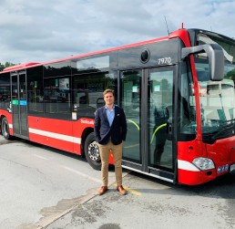
Petter Johansson, Business development manager, Arriva (picture above):
”Arriva sees a great value of understanding our customers travel patterns to be able to create a more attractive public transportation with an optimized timetable. In the SMART project, many different actors contribute with their respective data sources, which enables data-driven improvements to optimize traffic planning and accessibility. Through the SMART project, Arriva sees opportunities to optimize and streamline public transportation with customer needs in focus.”
SMART is an initiative to create a database of comprehensive information about all travelers’ movements, to plan and optimize public transport. The project will use data from many different sources, including wifi data from Bumbee Labs, vehicle data from Ramboll, Inrix and Tomtom and crowd data from Tre. The unique thing about SMART is that it makes data about how passengers move even in forms of travel other than the collective ones available.
New ways of measuring Traffic Flows and Air Quality in Kista
Combining measurements of traffic flows and air quality
Combining measurements of traffic flows and air quality
New ways of measuring traffic flows and air quality in Kista
The project
Kistagången and Urban ICT Arena’s testbed provides a great spot for testing new products and cases for a sustainable city. One big challenge for the cities of today is how to manage traffic, avoid congestions and provide a good urban environment.
Planning new traffic solutions and evaluating the effectiveness of changes made to the current environment requires data. In order to provide this, continuous measurements of traffic and the direct and indirect effects of traffic on the urban environment are necessary. By gathering relevant data and analysing them, city authorities may receive better support and bases for decisions, in turn leading to efforts that may lower pollution and reduce noise in the urban environment.
In this project, Edeva shows how combining several data sources at a fixed position in the test bed on Kistagången can contribute to more informed decisions for traffic management. Mounted on a light pole, the sensors measure traffic flow through radar and multi-sensor data, air quality in the form of particles, and noise. Analysing the data provided also makes it possible to draw conclusions about the effects of the traffic.
Project period
2021
Partners
Kista Science City
Edeva
Contact
Lucas Uhlén, Kista Science City
lucas.uhlen@kista.com
David Eskilsson, Edeva
david.eskilsson@edeva.se
Summary
One big challenge for the cities of today is how to manage traffic, avoid congestions and provide a good urban environment. Planning new traffic solutions and evaluating the effectiveness of changes made to the current environment requires data. In a new project in the testbed on Kistagången, Edeva shows how combining several data sources at a fixed position can contribute to more informed decisions for traffic management.
The purpose
The goal is to supply a comprehensive solution to provide municipalities and city authorities with data. This in turn will help with a more robust decision-making process. Measuring both traffic and the direct and indirect effects of that traffic provides better data which makes it possible to measure the effects of introduced solutions and measures to improve air quality and the general quality of the urban environment.
The combination of sensors may also provide insights into the effects of different types of traffic on the urban environment and air quality. The effects of traffic control on air quality and environment will also be measurable. In addition, the tests will provide data on how sensors behave in different conditions, such as light or weather. All in all, this trial will provide valuable data on how to create a secure, stable and cost-efficient solution for data gathering in the future.

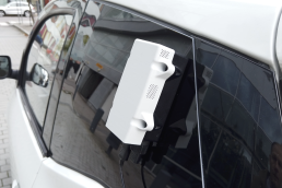
Vehicle as a Sensor: Air Quality
Vehicle as a Sensor: Air Quality
Vehicle as a Sensor: Air Quality
Mobile Air Quality Sensors Attached to Vehicles in Kista
The project
Air quality is a matter of life and death affecting the daily lives in our cities. When we collect real-time data of air quality in our connected cities, we could contribute to new solutions and prevent illness. Imagine a future where the bus automatically avoids the most polluted streets or if factories limit their production on certain days, thanks to connected sensors.
In Kista, new sensors for local air quality measurement are tested in a number of projects. In the project Vehicle as a Sensor: Air Quality, Edeva and Smart Sensor Devices explored the possibilities of air quality sensors attached to moving vehicles. The goal was to see how mobile sensors can provide data in ways that complements fixed sensors, and how these two types of measurements interact to provide a better picture of the situation.
Project period
2020
Partners
Kista Science City
Edeva
Smart Sensor Devices
Contact
Eleonor Sjödin Turah
eleonor.sjodinturah@kista.com
Summary
Taking advantage of vehicles used in a last-mile public transport project, Edeva and Smart Sensor Devices tested their air quality sensors by attaching them to the vehicles. This gave them the opportunity to measure both indoor air quality in the vehicles and take GPS-positioned measurements of air quality in the urban environment.
Air quality
The project collected real-time air quality data and use software to visualize and analyze the data. This would test the robustness of the sensors and systems, and how this would work in a real urban setting. The sensors were attached to the vehicles used in the Delta project, taking place between October and December of 2020.
The air quality sensors measured two types of air quality. The sensors from Smart Sensor Devices measured air quality inside the vehicles, while the sensors from Edeva measured air quality in the urban environment around the vehicles. The Edeva readings used GPS positioning to keep track of where those readings were taken, and given a time stamp.
Measurements of air quality are important for different decision-making processes regarding traffic and planning of the urban environments. Many measurements are, however, bound to fixed positions, which will give a snapshot rather than a comprehensive picture of the city. Proving the concept of mobile, GPS-positioned measurements taken continuously will assist municipalities and city authorities in complementing their data in order to have a better foundation for future decisions. Indoor measurements of air quality also helps with this process, as it may give data on how indoor environments are affected by the surrounding environment. It also gives important data about the work environment.
Takebacks
One important takeback from the trials performed within the scope of the project was that it proved to be valuable to measure random, on-demand voyages rather than regular public transports moving on a time table. This enabled measurements on several different locations and times that might otherwise have been missed. It also gives a better picture of “where people are” rather than only the main thoroughfares in an area.
Moving forward
Moving forward, the next steps for the air quality sensors will be to get regular measurements in a larger urban environment. Taking measurements with even shorter intervals, and combining the mobile sensors with fixed sensors at key locations to look more in-depth at certain variables will probably be the optimal combination to provide good data for municipalities and city authorities in the future. This will also provide data over time to see changes from implemented solutions in the environment.