
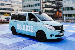
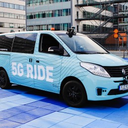
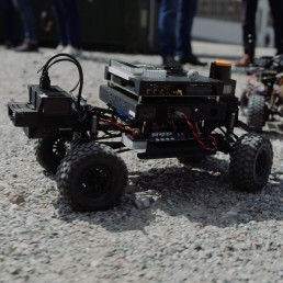
Seeing through obstacles and around corners, the 5G Ride project rolls on
Drones
Seeing through obstacles and around corners, the 5G Ride project rolls on
The 2022 5G RIDE Demo Day on October 13 gathered more than 50 special invited guests and project partners who got a sneak preview of the latest technology updates.
This year’s demonstration focused on how new technology can be used to increase safety and security around autonomous vehicles in commuting traffic, hence offering a safer experience for travellers and other road users. The visitors got to experience how smart sensors on vehicles and in the surrounding infrastructure makes it possible for the vehicle to see through obstacles and around corners.
The sensors are an important addition to the project, as they measure positions and paths/route for all road users and sends this data in real time to Ericsson Innovation cloud, via 5G, where the data is processed, combined with other sources, and shared with the connected vehicle. The vehicle is acting upon the combined picture, from sensors, traffic tower, own cameras and the surrounding. In real time. During the demonstration we could see what happens if a person crosses the street if there is an obstacle on the path and how buildings and people are plotted on the onboard screens.
The technology enabling this is the 5G network and the traffic tower, as they fetch and share real-time data from the vehicle.
The ambition of the 5G RIDE project is to create conditions for an efficient and sustainable public transport where operators in traffic towers can support fleets of autonomous, electric vehicles to improve traffic planning, safety and reduce energy consumption. By taking a unified approach and combining technologies, the next step in the development of driverless automated vehicles is taken.
This project takes place in a collaboration between some of Sweden’s leading companies in mobility and technology. Kista Science City AB, Keolis, Ericsson, Telia, T-engineering, Viscando, Scania, Region Stockholm, intel and KTH. Working together to create a more environmentally smart and cost-efficient transport system.
For more information about the project
project manager Eleonor Sjödin Turah
eleonor.sjodinturah@kista.com
Sign up to get the latest news, updates and insights from Kista Science City

SMART
SMART
Intelligent traffic system
The project
Traffic congestion is a huge problem in urban areas. In Stockholm, car owners spend about 16 workdays stuck in traffic each year. Public transport is also affected by this, and during rush hours, bus services can suffer huge delays.
The objective of the Spatial Modelling Analytics & Real-time Tracking (SMART) Mobility Project is to mitigate growing urban traffic congestion challenges and associated issues of environmental degradation, economic inefficiency and negative impacts to the quality of life of citizens.
SMART Mobility will revolutionise the efficiency of traffic and commuting in cities by leveraging the capabilities of new 4D spatial technology and analysis platforms using real-time vehicle location and various movement data.
Several data sets
The project will use data from many different sources, including:
- Wifi data from Bumbee Labs. Position data is collected when smartphone searches for WiFi-connectivity. Bumbee Labs technologies utilizes this for crowd measurements and pedestrian flow, which is compliant with GDPR regulations.
- Vehicle data from Ramboll, Inrix and Tomtom. Through GPS, data such as speed and route can be obtained.
- Crowd data from Tre. Anonymize crowd data obtained from different sources, like cellular data and WiFi.
Project period
2020-2022
Partners
Ramboll
Bumbee Labs
Savantic
Tre
RISE
Contact
Eleonor Sjödin Turah
eleonor.sjodinturah@kista.com
Summary
SMART is a project that aims to create more effective traffic planning, with focus on public transport. The project will result in a prototype for a new platform, where many different data sets will interplay with AI technologies to predict congestion and plan routes accordingly.
The platform
The platform will be open and transparent for information and data exchange. The data sets can then be used for new types of services and applications, such as new routes for public transport and analyzing the size of a bus fleet. Through visualisation, this can be used to plan for a more effective public transport. In the end, this will benefit the end users – the travellers.
The project
The project aims to:
- Conduct three use cases in the Kista-Järva area
- Build the SMART-platform
- Integrate data sets into the platform
The anticipated result of the project is to completely integrate siloed data using 4D location. A real-time, shared and collaborative application platform will give access to multiple stakeholders. Furthermore, SMART will optimize mobility in the existing transportation network on a massive scale
Subscribe to newsletter
Error: Contact form not found.

Drones – a natural layer in the future transport system
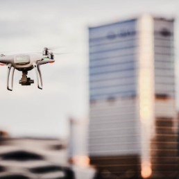
Drones
Drones – a natural layer in the future transport system
What impact will the new U-space regulations, Sustainable Urban Mobility Planning and UAMs have on Swedish authorities and entities? This topic was discussed at an event earlier this year, part of the test and demo activities in Fordonsdalen.
A broad range of stakeholders from the City of Stockholm, Region Stockholm, Luftfartsverket, Ericsson and several Stockholm based small and middle sized enterprises (SME) gathered to discuss and demonstrate the role drones will have in our future cities.
Raising awareness on how to drive a sustainable and responsible transition of urban mobility
The purpose of the meeting was to raise awareness on how to drive a sustainable and responsible transition of urban mobility into space, or the third dimension.
A vital part of the event was the discussion on how municipalities should implement the new upcoming U-space regulations, and the role of innovative SME’s in this process, showcasing safe use cases, eg data collection and inspection of first and last mile deliveries. In order to to shape the future of mobility we must have a common understanding from all parties, authorities, municipalities, researchers and startups.
Three small-sized innovative companies had the opportunity to present their solutions during the meeting;
–Skyqraft – visual data analytics provider helping businesses in the linear infrastructure sector to make better decisions about grids,
–Skysense, experts in the area of tracking aircraft, the growing field of aircraft safety and protection against drone;
–Aerit – a sustainable drone delivery service based in Stockholm.
“Unmanned aerial vehicles, or more commonly, drones, are already in use in our society for different purposes such as data collection and infrastructure inspections. The possibilities of using drones in the urban environment are endless. To establish a good balance of what use cases the citizens need and the the ones that will have the most impact in terms of environmental and social sustainability, the collaboration between the public and private sector is key.”
— Sara Nozkova, Mobility Lead at Kista Science City and project manager for the Test & Demo activities within Fordonsdalen.
Call for action
Are you too a Stockholm-based SME developing solutions with the potential to transform the automotive industry and transportation system? Would you like to demonstrate your solution to a wider audience, or test together with a potential business partner within the ICT or automotive sector? Please contact sara.nozkova@kista.com.
Sign up to get the latest news, updates and insights from Kista Science City
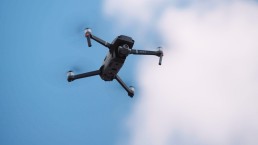
Nordic drone initiative
Nordic drone initiative
A platform for exchange of ideas between the Nordic countries and the rest of the world
The project
Together with other innovation clusters in the Nordics, Kista Science City founded the Nordic Drone Initiative. This project will strengthen the ties between the different clusters and help companies working with drones to learn from neighbors and form new alliances.
During the project duration, Kista Science City will represent its partners interests in dialogs with the Nordic cluster organizations, cities, and drone companies. The project creates a unique collaboration platform (first of its kind in the Nordics!) to discuss the various use areas for drones in the cities. And as the next step, act upon them through tests in real urban environment, such as Kista.
Partners
VTT, RISE, NORCE, Robots Expert, Bell Rock Advisors, Avinor, Katla Aero, Drone Nord, Gate 21, Mainbase, Flypulse, Nordic Edge, UAS Norway, LFV, Östergötland, Business Tampere
Funded by
Nordic Innovation
Summary
Together with other innovation clusters in the Nordics, Kista Science City founded the Nordic Drone Initiative. This project will strengthen the ties between the different clusters and help companies working with drones to learn from neighbors and form new alliances.
The purpose
- To identify and evaluate how drones can be used in the transport sector to provide the greatest benefit to society, business and the environment.
- Map the Nordic ecosystem for drones and the opportunities that this technology provides.
- Contribute to the development of drone technology for Nordic weather conditions.
- Propose the development of rule changes that enable drone transports and large-scale operations with vertical take-off and landing.
- Create a platform for continued research and innovation and developed international cooperation.
NDI members enjoy access to a unique network of drone experts, insights and further research/commercial project opportunities (e.g. H2020) with top Nordic drone organisations. NDI accepts new members with emphasis on commercial actors able to contribute resources in the development work.
Funded by Nordic Innovation
Nordic Innovation is an organization under the Nordic Council of Ministers and aims to make the Nordics a pioneering region for sustainable growth and works to promote entrepreneurship, innovation and competitiveness in Nordic business. Nordic Innovation supports programs and projects which contribute in fulfilling the goals of the Cooperation Program for Innovation and Business 2018-2021 which is decided by the Nordic Ministers for Business and Innovation.
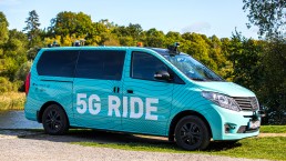
5G Ride
5G Ride
Autonomous vehicles
The project
5G Ride is a concept for self-driving, 5G-connected electric vehicles used in public transport.
The purpose of the project is to develop and test connected autonomous vehicles to get closer to an implementation of autonomous vehicles on public roads.
The 5G network’s unique technical features, including enhanced security, extremely high data speeds combined with low latency, means that the connected buses can respond in real time to commands from the centralized control tower.
In 2021, additional funding was added to the project and the focus for the continuation of the project is the further development of the Connected Control Tower. One part of this is how to use more data, for example about the route, the vehicle or the connection strength, to make it possible to prevent any problems, plan routes and schedules better and act more swiftly should problems arise.
Project period
2020-2025
Partners
Keolis
Ericsson
Telia
Intel
Scania
Viscando
T-Engineering
Royal Institute of Technology
City of Stockholm
Region Stockholm
KTH
AppliedAutonomy
VY
Contact
Eleonor Sjödin Turah
eleonor.sjodinturah@kista.com
Summary
5G Ride is a concept for self-driving, 5G-connected electric vehicles used in public transport.
The pilot
The pilot in 2020 was the result of a unique collaboration between some of Sweden’s most prominent and well-known organizations within the fields of mobility and technology.
The knowledge hub and testbed Urban ICT Arena managed the initiative, with Keolis as bus operator. Ericsson provided the technical solution for the connected control tower, a solution that will be further developed during 2021.
Telia provideded the 5G-connectivity in collaboration with Ericsson and deployed 5G at Djurgården specifically for this project. Intel delivered analytics capabilities and the technology for the processing across the network including the IT-system in the vehicles and the control tower, as well as the mobile network. T-Engineering, a Swedish technology firm, delivered vehicle and self-driving technology.
HRH Prince Daniel was among the dignitaries to attend the official inauguration ceremony outside Tekniska museet.
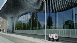
Urban robots and shared micro mobility
Autonomous vehicles
Urban robots and shared micro mobility
Test & demo activities for Fordonsdalen took off with full speed this earlier this year!
At a demonstration day in June, part of Kista Mobility day 22, smaller growth companies with solutions for autonomous robots and smart city infrastructure were invited to put their innovations on display for a wide audience of decision makers, researchers, public sector representatives and potential business partners in the automotive and ICT industries.
The attendees could dive into cutting-edge solutions aiming to increase the pace of transition, strengthen the innovation power and business development for the city’s mobility systems.
“AI-powered autonomous robots are reshaping urban spaces and city life already today. Cities are at the center of the technological changes fueled by the fourth industrial revolution such as automation and artificial intelligence. We see a rapid development of a range of technologies addressing urban challenges.”
–says Sara Nozkova, Mobility Lead at Kista Science City and project manager for the Test & Demo activities within Fordonsdalen.
The companies demonstrating their solutions in Kista, eg ABConnect and Teraki, showcased how autonomous robots can be integrated into the urban landscape to provide smarter and more sustainable, and effective solutions in many areas, such as last-mile goods delivery, and security tasks.
Collaboration is key
New tech solutions is not all. New solutions for smart infrastructure are needed in order to complement the new first and last mile solutions. Nektta and Livelo are two great example of Stockholm-based companies developing new ways to support people getting around the city in a sustainable way, and to re-think the concepts of shared micromobility. Shared micromobility is an innovative sustainable mode of transport that can replace short-distance travel and has the potential to provide many environmental benefits.
Call for action
Are you too a Stockholm-based small or middle-sized company developing solutions with the potential to transform the automotive industry and transportation system? Would you like to demonstrate your solution to a wider audience, or test together with a potential business partner within the ICT or automotive sector? Do not hesitate to send an e-mail to lucas@uhlen@kista.com
Measuring traffic and people flows in Kista and Sollentuna
In Stockholm, car commuters may be forced to spend the equivalent of 16 days in traffic queues for one year. Public transport buses are also heavily affected by congestion and queues.
The objective of the Spatial Modelling Analytics & Real-time Tracking (SMART) Mobility Project is to mitigate growing urban traffic congestion challenges and associated issues of environmental degradation, economic inefficiency and negative impacts to the quality of life of citizens.
SMART started in December 2020 and is now moving from inventory and analysis phase to IRL measurements, in traffic.
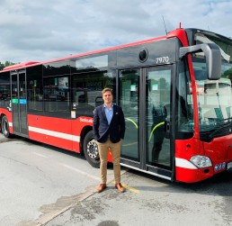
As we begin the first measurement period – where we take traffic from Ekerö to Kista and Sollentuna – we are taking the next exciting step in the SMART project. Among other things, we will take a closer look at travel on the bus routes that the transport contractor Arriva runs for Stockholm Public Transport:s (SL) – lines 176, 177 and 179 – where special units will be set up to see passenger flows. During that period, June-September, we will gain valuable insights into what travel to and from Kista and Sollentuna looks like from different areas of Stockholm, what travel patterns look like, etc., so that we can plan and perform public transport in a good way.
Petter Johansson, Business development manager, Arriva (picture above):
”Arriva sees a great value of understanding our customers travel patterns to be able to create a more attractive public transportation with an optimized timetable. In the SMART project, many different actors contribute with their respective data sources, which enables data-driven improvements to optimize traffic planning and accessibility. Through the SMART project, Arriva sees opportunities to optimize and streamline public transportation with customer needs in focus.”
SMART is an initiative to create a database of comprehensive information about all travelers’ movements, to plan and optimize public transport. The project will use data from many different sources, including wifi data from Bumbee Labs, vehicle data from Ramboll, Inrix and Tomtom and crowd data from Tre. The unique thing about SMART is that it makes data about how passengers move even in forms of travel other than the collective ones available.
Delta
DELTA
DELTA
DELTA was a pilot project in Kista Science City, organized by Kista Science City, Ericsson, Intel, Keolis and Telia.
The project
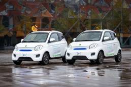
The project DELTA explored the possibilites of on demand last mile-solutions as a part of public transport. The electric cars took riders from door to door and connected public transit hubs with destinations within Kista.
The users was able to download an app and then connect with one of the vehicles in Kista. Both the business district (“Kista Science City”) and the residental area was included in the first stage of testing.
Project period
2021
Partners
Keolis
Ericsson
Intel
Telia
Contact
Eleonor Sjödin Turah
eleonor.sjodinturah@kista.com
Summary
The project DELTA explored the possibilites of ridesharing as a part of public transport. The project was centeredd around Kista in northern Stockholm and offer ridesharing "last mile" vehicles free of charge to users in the area.
Starting point: User Experience
Within DELTA, we focused on the user experience in its entirety to investigate and evaluate customer experience with this unique service in order to find out what attributes the service needs to provide to become attractive to the target groups – in other words, what criteria it needs to fulfil in order for customers to choose it over other first/last mile mobility solutions (micromobility) and private cars.
Testing period
The pilot was launched during autumn in 2020 and continued until early December. The project was funded by Drive Sweden and Vinnova.
New ways of measuring Traffic Flows and Air Quality in Kista
Combining measurements of traffic flows and air quality
Combining measurements of traffic flows and air quality
New ways of measuring traffic flows and air quality in Kista
The project
Kistagången and Urban ICT Arena’s testbed provides a great spot for testing new products and cases for a sustainable city. One big challenge for the cities of today is how to manage traffic, avoid congestions and provide a good urban environment.
Planning new traffic solutions and evaluating the effectiveness of changes made to the current environment requires data. In order to provide this, continuous measurements of traffic and the direct and indirect effects of traffic on the urban environment are necessary. By gathering relevant data and analysing them, city authorities may receive better support and bases for decisions, in turn leading to efforts that may lower pollution and reduce noise in the urban environment.
In this project, Edeva shows how combining several data sources at a fixed position in the test bed on Kistagången can contribute to more informed decisions for traffic management. Mounted on a light pole, the sensors measure traffic flow through radar and multi-sensor data, air quality in the form of particles, and noise. Analysing the data provided also makes it possible to draw conclusions about the effects of the traffic.
Project period
2021
Partners
Kista Science City
Edeva
Contact
Lucas Uhlén, Kista Science City
lucas.uhlen@kista.com
David Eskilsson, Edeva
david.eskilsson@edeva.se
Summary
One big challenge for the cities of today is how to manage traffic, avoid congestions and provide a good urban environment. Planning new traffic solutions and evaluating the effectiveness of changes made to the current environment requires data. In a new project in the testbed on Kistagången, Edeva shows how combining several data sources at a fixed position can contribute to more informed decisions for traffic management.
The purpose
The goal is to supply a comprehensive solution to provide municipalities and city authorities with data. This in turn will help with a more robust decision-making process. Measuring both traffic and the direct and indirect effects of that traffic provides better data which makes it possible to measure the effects of introduced solutions and measures to improve air quality and the general quality of the urban environment.
The combination of sensors may also provide insights into the effects of different types of traffic on the urban environment and air quality. The effects of traffic control on air quality and environment will also be measurable. In addition, the tests will provide data on how sensors behave in different conditions, such as light or weather. All in all, this trial will provide valuable data on how to create a secure, stable and cost-efficient solution for data gathering in the future.